Home > Arts > Photorealistic artworks > Detailed art pieces > Masterful detailing in art
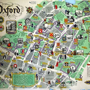
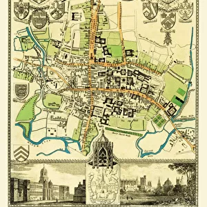
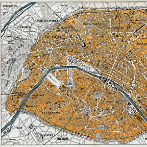
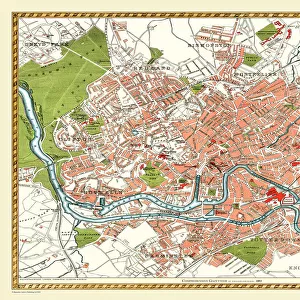
Old Map of Oxford 1808 by Cole and Roper

![]()
Wall Art and Photo Gifts from MapSeeker
Old Map of Oxford 1808 by Cole and Roper
An attractive and detailed early 19th century reproduction plan of the City of Oxford 1808. First published by Cole and Roper as a finely engraved series of county maps and town plans which were initially issued in parts and then together as The British Atlas in 1810
Welcome to the Mapseeker Image library and enter an historic gateway to one of the largest on-line collections of Historic Maps, Nostalgic Views, Vista's and Panorama's from a World gone by.
Media ID 20348108
© Mapseeker Publishing Ltd
Cole And Roper Historic Map Old Town Plan
FEATURES IN THESE COLLECTIONS
> Arts
> Photorealistic artworks
> Detailed art pieces
> Masterful detailing in art
> Maps and Charts
> Early Maps
> Maps and Charts
> Related Images
> MapSeeker
> British Town And City Plans
> English & Welsh PORTFOLIO
EDITORS COMMENTS
This print showcases an exquisite and intricately detailed reproduction of the "Old Map of Oxford 1808" by Cole and Roper. Transporting us back to the early 19th century, this historic town plan offers a fascinating glimpse into the City of Oxford's past. Originally published as part of a meticulously engraved series of county maps and town plans, this particular map was first issued in parts before being included in The British Atlas in 1810. Its remarkable level of detail is truly awe-inspiring, capturing every nook and cranny of this ancient city with precision. As we explore this old map, we are drawn into a world where cobblestone streets wind through bustling markets, grand cathedrals stand tall against the skyline, and charming neighborhoods exude their unique character. Each building is carefully depicted, allowing us to envision life as it once was within these historic walls. The charm and allure emanating from this vintage print make it an ideal addition for history enthusiasts or anyone captivated by the rich heritage that Oxford holds. Whether displayed on a study wall or adorning a coffee table book about local history, this Old Map of Oxford serves as both an educational resource and a beautiful piece of art that celebrates our connection to the past.
MADE IN THE USA
Safe Shipping with 30 Day Money Back Guarantee
FREE PERSONALISATION*
We are proud to offer a range of customisation features including Personalised Captions, Color Filters and Picture Zoom Tools
SECURE PAYMENTS
We happily accept a wide range of payment options so you can pay for the things you need in the way that is most convenient for you
* Options may vary by product and licensing agreement. Zoomed Pictures can be adjusted in the Cart.